Lynching Map
From WikiMarion
(Redirected from Lynchingproject-map)
The map below includes places pertaining to the Marion lynching.
<googlemap lat="40.546939" lon="-85.658512" zoom="13" width="800" height="500" controls="large">
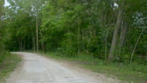
40.525234, -85.624845,Lovers Lane: The exact location is unknown because the name of the road was given by the townspeople. The records indicated the road as Todd Street.
 .
.
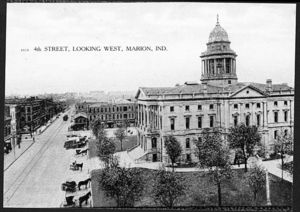
40.558295, -85.659227, Grant County Courthouse: 


Grant County Jail: This is where the accused Tom Shipp, James Cameron, and Abram Smith waited all day as a mob of angry townspeople began to accumulate outside on August 7, 1930.
40.550763, -85.69028, The Residence of Mary Ball and her family. ("Bullet Wounds Prove Fatal to Holdup Victim") 40.528285, -85.663505, The Residence of Abram Smith: The location according to the City Directory 1929. 40.557169, -85.658398, Marion Malleable Iron Works: The Marion Iron Works employed Tom Shipp up until his alleged rape of Mary Ball and the murder of Clyde Deeter. 40.552263, -85.693274, Northern Indiana Power Track Station Shoe Parlor: This was the place at which James Cameron was employed up until his alleged involvement in the rape of Mary Ball and the murder of Claude Deeter.
40.558034, -85.658576,East Side of Court House: Just off the screen to the North side of the image below is the tree at which Tom Shipp and Abram Smith were hung in the night of August 6,1930.
40.557895, -85.659349, 

</googlemap>
Work Cited
- Bullet Wounds Prove Fatal to Holdup Victim. Marion Chronicle August 7. 1930. Page 1 Column 7. Print.
- City Directory 1929 Vol. 1